Hickison Summit

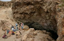
Hickison Summit is located on Highway 50, around 30 miles southeast of Austin at the northern end of the Toiyabe Range and situated within a pinyon forest. The site is located on the road to the ranch of John Hickerson (also an alternative spelling of the site name) after whom the site was named. This site was interpreted as a hunting locality by Trudy Thomas because the most common motif at the site was thought to represent “hoof prints.”
An alternate interpretation identifies the marks as vulviforms (representations of female genitalia), possibly indicating that the site was the location of girls’ puberty rituals or the locale for a female cult of affliction centered on reproductive disorders. Similar marks are generally found on soft, white volcanic tuff and are often repeated in large numbers, which may well be an indicator of ritual activity. The non-random distribution is also suggestive of locations being intentionally selected for this specific quality. Perhaps the soft rock was easier for the initiates to carve into as a part of their ritual. There is no historic ethnographic record, however, of girls producing rock art as a part of their puberty ritual, which was primarily focused on instruction by older women on the roles and duties of womanhood.
Hickison Summit has been developed by the Bureau of Land Management for public enjoyment, with a scenic interpretive trail, camping and picnic facilities, and restrooms. The site is open year-round, but may be difficult to access in winter due to snow and mud.
Article Locations
Related Articles

Further Reading
None at this time.