Lake Mead

Photographs in the Carol M. Highsmith Archive, Library of Congress, Prints and Photographs Division.
Lake Mead National Recreation Area, formed by the creation of Hoover Dam, Nevada

Photograph courtesy of Library of Congress, Prints & Photographs Division, HAER, Reproduction number HAER NV-40-1
Route No. 1 near east end, view toward Overton Beach and Lake Mead, view to northeast - Route No. 1-Overton-Lake Mead Road, Between Overton Beach & Park Boundary, 6 miles south of Overton, Overton, Clark County, NV
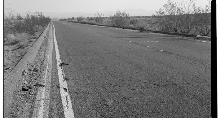
Photograph courtesy of Library of Congress, Prints & Photographs Division, HAER, Reproduction number HAER NEV,2-BOUC.V,1--1.
Roadview 1/8 mile north of Lake Mead National Recreation Area entrance sign, east of Henderson, Nevada, facing northeast -- Lakeshore Road, Boulder Basin, Boulder City, Clark County, NV.
Photographs in the Carol M. Highsmith Archive, Library of Congress, Prints and Photographs Division. Reproduction number: LC-DIG-highsm-16237.
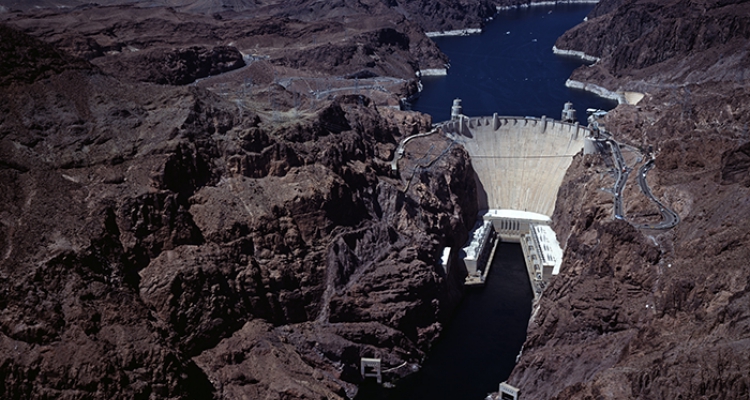
Aerial view of Hoover Dam, near Boulder City, Nevada, with the Lake Mead National Recreation Area, which the dam's blocking of the Colorado created, in the distance.

Photographs in the Carol M. Highsmith Archive, Library of Congress, Prints and Photographs Division. Reproduction number: LC-DIG-highsm-18116.
Lake Mead National Recreation Area, created by the building of Boulder (later Hoover) Dam, Nevada


Lake Mead, a man-made lake 25 miles southeast of Las Vegas and created by the completion of Hoover Dam in 1935, is the largest reservoir in the United States. Located within the 1.5 million-acre Lake Mead National Recreation Area, this enormous lake stretches along a 140-mile section of the lower Colorado River Basin near the southern tip of Nevada and extends east into the edge of the Grand Canyon in western Arizona. A major flood control reservoir for water flowing southwest down the Colorado River, Lake Mead can hold up to two years’ worth of the river’s average flow. When its water level reaches about 1,221 feet elevation, the lake contains 9.3 trillion gallons of water covering 247 square miles.
The water supply stored at Lake Mead has been vital to the development of the America’s arid Southwest since the 1930s. Each year, the lake’s water, managed by the U.S. Bureau of Reclamation, flows from the diverted Colorado River south through Hoover Dam for drinking water and to irrigate about 3 million acres of land in Nevada, Arizona, and California (Mexico is also guaranteed some of the flow for drinking and irrigation). Water streaming from Lake Mead into Hoover Dam’s power plant generates on average about 4.2 billion kilowatt hours of electricity per year (it produced a high of 10.3 billion kilowatts in 1984) that is shared by Nevada, Arizona, and southern California. The lake is named after Elwood Mead, the commissioner of the Bureau of Reclamation from 1924 to 1936 who oversaw its formation.
In southern Nevada, Lake Mead is critical to the area’s human population, and its falling water levels are of great local concern. The lake provides 90 percent of the drinking water for the Las Vegas metropolitan area (pop. 1.8 million in 2008). The water is delivered to the Las Vegas Valley via two large intake tunnels or “straws” sunk beneath the bottom of the lake.
Lake Mead’s water level, typically highest from late fall to early spring before desert heat drives it down, remain high when more water flows in than flows out. But its changing levels have shrunk since the late 1990s, due to prolonged drought conditions in the Rocky Mountains, where an immense melting snow pack provides most of the water winding down the Colorado River through Lake Powell in Arizona before settling into the Lake Mead reservoir. Federal officials place Lake Mead’s maximum fill level at 1,229 feet. The lake reached its highest level, 1,225 feet, in 1983. However, the water table plunged in 2000 when the runoff from melting snow was only 56 percent of normal. Wetter winters in 2004 and 2005 contributed to higher levels, but not for long. As of the fall of 2009, the lake’s water had receded to 1,093 feet above sea level, a point not seen since 1965. The Bureau of Reclamation reported in 2009 that the average natural flow of water down the Colorado River toward Lake Mead, recorded at Lees Ferry, Arizona from 2000 to 2009, was 11.9 million acre feet, “the lowest ten-year average in over 100 years of record keeping on the Colorado River.”
If the lake’s surface declines to 1,050 feet, one of its two intake straws will be no longer able to remove water from the lake. The second intake goes down to about 1,000 feet. The U.S. government has estimated that the lake’s water must be at least 1,050 feet deep for Hoover Dam to generate power. Declining water supplies also may force some commercial boating operations on Lake Mead to build new boat launches closer to retreating shorelines.
The Southern Nevada Water Authority, provider of the Las Vegas Valley’s water supply, arranged in 2009 to construct a third intake tunnel, 20 feet in diameter, 15,000 feet long and capable of drawing water from beneath the lake bed down to 860 feet. The new intake tunnel and its pumping station, to cost $500 million, are expected to begin operating by 2013. But in order to plan for the possibility of further water losses at Lake Mead, the Southern Nevada Water Authority has proposed to build a vast system of pipes to tap ground water from counties in rural eastern Nevada to the Las Vegas Valley.
History of the area around Lake Mead
Before 10,000 B.C., the area that is now Lake Mead had a colder and damper environment with more vegetation and inhabited by animals such as plant-eating southern mammoths, ground sloths, American horses and ancient camels. Early Native Americans, according to some researchers, may have appeared in the vicinity as early as 8,000 B.C. But the first recognized culture of humans in the area, known at the Basketmakers, lived from about 300 to 500 B.C. beside the Muddy River in the far upper north end of modern-day Lake Mead (near the town of Overton, Nevada). In the 1920, a series of ruins of ancient Indian adobe pueblos were discovered in this area, known later as “El Pueblo Grande de Nevada” (The Lost City). From 1925 to 1926, archeologist Mark Harrington led an excavation crew that unearthed more than 40 pueblos where the Basketmakers once lived. A few years later, also on the Muddy River, Harrington uncovered the former dwellings of Pueblo Indians, later estimated to have lived there from about 700 to 1150 A.D., when they moved east for Arizona and New Mexico.
In the 19th Century, white European explorers passed through the surrounding area by way of the Colorado River, including Jedediah Smith in 1826 and Lt. Joseph Ives in 1855. The most famous early white explorer was John Wesley Powell. In 1869-70, Powell, a geologist on a surveying mission, traveled 1,500 miles with 10 men in several boats down the Green River in southwest Wyoming, then on the rapids of the Colorado River through Utah to the Grand Canyon in Arizona and the Virgin River, at the upper section of today’s Virgin River Basin in the northern end of Lake Mead.
Why Lake Mead was created
The origin of the Lake Mead reservoir can be traced to the desire by the United States government and agriculture businesses to tame, divert and dam the Colorado River, the largest river in the western United States. The Colorado was considered unpredictable and prone to major flooding as more Americans moved westward in the late 19th and early 20th centuries and sought to channel its flow for farming.
In 1902, President Theodore Roosevelt signed the Newlands Reclamation Act, legislation authored by Nevada Congressman Francis G. Newlands, to manage water flows and promote crop irrigation by building dams on rivers in 17 Western states. One such river investigated by the U.S. government was the Colorado, an ancient water source originating primarily from the Rocky Mountain range near Denver, Colorado, proceeding southwestward through canyons in southern Utah, northern Arizona, southern Nevada and western Arizona before stopping in northwestern Mexico short of the Gulf of California.
The Colorado River would reveal its volatility soon, in 1905, when an attempt to divert the river with a temporary canal triggered a massive spill into Lake Cahuilla in southern California’s Imperial Valley. The Colorado’s entire uncontrolled flow continued to stream there until 1907. Flood waters immersed crop land and formed what became known as the Salton Sea that remains today the largest lake in California. Farmers in the Imperial Valley asked the U.S. government to build a canal at the river to prevent flooding. In 1916, flood waters from the Gila River carried into the Colorado and flooded the Yuma Valley near the Salton Sea. Two years later, the director of the Reclamation Bureau, Arthur P. Davis, suggested controlling the Colorado by building a dam of record height at Boulder Canyon in southern Nevada. In 1922, the Secretary of the Interior issued a report on flood prevention in the Imperial Valley that also proposed damming the Colorado at Boulder Canyon. In 1928, six states bordering the Colorado River Basin signed the Colorado River Compact to apportion shares of water, in acre feet per year, from the river to its upper and lower basins, but not yet to the states.
President Calvin Coolidge signed into law the Boulder Canyon Pact for the dam, to be located at a place known as Black Canyon between Nevada and Arizona, in 1928. Planning for the Boulder Dam project (later renamed Hoover Dam after President Herbert Hoover) started the following year and building began in 1931. In addition to flood control and water storage, the dam’s planners added electrical power generation to its functions. The first task for builders was to divert the Colorado River itself by installing coffer dams to bypass the Boulder Dam site during construction.
Filling the canyon that became Lake Mead came at the cost of St. Thomas, a 19th century ranching town off of the Muddy River at the far northern end of where the lake is today. St. Thomas was established in 1865 by Mormon pioneers sent from Utah by leader Brigham Young. The town at one point had a population of 500 people, a post office, a two-story hotel and a cemetery. But in the 1930s, the U.S. government informed its residents of the coming of Lake Mead and bought up their land. Many of those who chose to stay in the area moved north of the lake to Overton. The graves in the cemetery were relocated on high ground nearby. By 1935, the 726-foot high Hoover Dam was completed and water began to flow into the canyon. Inside a row boat, the last resident of the now-flooded St. Thomas left in 1938. As water continued to collect in the reservoir, the foundations of former buildings in St. Thomas were completely submerged. However, St. Thomas didn’t remain an underwater ghost town. In the early 2000s, as Lake Mead’s water levels receded during a protracted drought, the old foundations of St. Thomas reappeared, permitting visitors to traipse amid the town’s ruins.
Lake Mead National Recreation Area
In 1964, the federal government chose the banks surrounding Lake Mead to serve as America’s first-ever national recreation center. The Lake Mead National Recreation Area attracts 9 million visitors per year. Its 1.5 million acres includes facilities for camping, hiking, boating, sport fishing, swimming, canoeing, kayaking, waterskiing and jet skiing in Nevada and Arizona. It has seven marinas, nine paved launch sites for boats and more than 600 sites for camping and recreational vehicles for visits lasting up to 30 days. The recreation area’s 550 miles of shoreline stretches far south past the Lake Mead reservoir and Hoover Dam to Davis Dam and a separate reservoir, Lake Mohave, and to the far east through the winding Temple Basin and Gregg Basin, Iceberg Canyon, the Grand Wash Bay and then south to the western edge of the Grand Canyon National Park.
In the western part of Lake Mead, within Boulder Basin on the Nevada side, is the Las Vegas Boat Harbor, including Hemenway Harbor and the Lake Mead Marina, used to dock and launch private boats for day rides, paddle wheeler boats for cruises to Hoover Dam, and houseboats for evening dinner cruises and overnight cruises that sleep up to 12 people. Boulder Beach is a graded area on the western shore for swimming and sunbathing beside a campground and RV village. The Callville Bay Resort, a marina to the northeast, has powerboats for touring and waterskiing, fishing boats, houseboats, patio boats and boat slips for rent, a restaurant, lounge, general store and campground.
Other marinas for boating include the Echo Bay Resort, located further north on the western side of the lake’s Overton Arm that extends to its northernmost point at the town of Overton and just east of the Valley of Fire State Park. The Temple Bar marina is in Temple Basin on the lake’s eastern shore in Arizona.