Nevada Test Site Overview
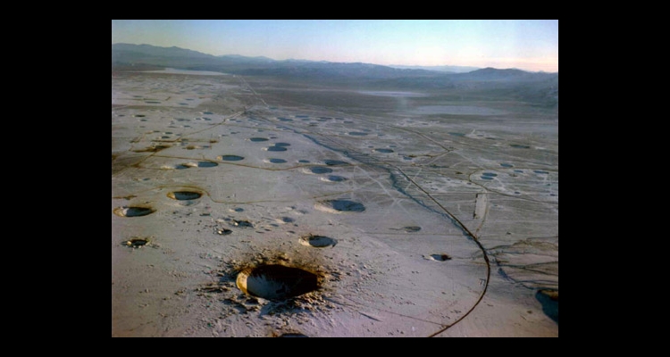
Photo courtesy of National Nuclear Security Administration / Nevada Site Office.
Cratering from underground nuclear tests looking south along Yucca Flat. The large crater at the bottom of the photograph is the Sedan Crater.

Photograph courtesy of Peter Goin.
In the above-ground test conducted on this site, the nuclear device was positioned on top of a tall tower for detonation. The great force of the blast caused the tower to disintegrate, leaving only its base. The land in this area is still contaminated with alpha particles, although the surface has been bulldozed. [Taken from the book Nuclear Landscapes, by Peter Goin.]
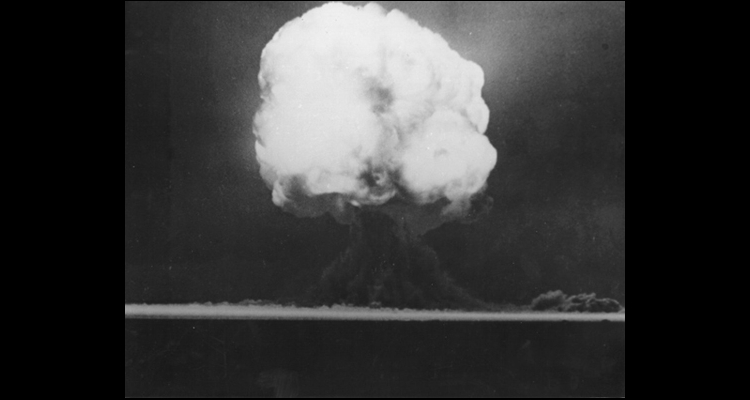
Mushroom cloud of The Trinity Test. Image captured 15 seconds after detonation on July 16, 1945 in the desert near San Antonio, New Mexico.

Photograph courtesy of Peter Goin.
This surviving trial railroad trestle stands in Frenchman Lake, Yucca Flat. This bridge, the only remaining section of an elevated railroad, was located 1,800 feet from ground zero and received overpressures exceeding 450 pounds per square inch. The blast blew sections of the structure off the foundation and bent large I-beam girders. This detonation, code named "Priscilla," had 37 kilotons of force. By comparison, the blast at Hiroshima measured 13 kilotons. [Taken from the book Nuclear Landscapes, by Peter Goin.]
Photograph courtesy of Peter Goin.
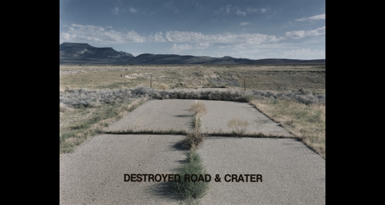
This road was constructed along the northeastern edge of Yucca Flat and used in preparation for an underground nuclear test. A drilling crew then prepared the site for ground zero—right in the middle of the road, about 1,500 feet below the surface. The detonation destroyed the road and created this subsidence crater (the ground collapses into the cavity by the blast). [Taken from the book Nuclear Landscapes, by Peter Goin.]
Formerly the Nevada Proving Grounds, the Nevada Test Site is located in Nye County about sixty-five miles northwest of Las Vegas, and covers approximately 1,375 square miles. The site begins at the town of Mercury in the southeast and ends at Pahute Mesa in the northwest. It borders the Nellis Test and Training Range and Area 51 at Groom Lake, and it contains portions of Yucca Mountain where the federal government has proposed the construction of an underground nuclear waste storage site.
Between 1951 and 1992, nine hundred and twenty-eight documented atmospheric and underground nuclear tests occurred at the Test Site. A three-year moratorium on nuclear testing occurred between 1958 and 1961. On August 5, 1963, the United States, Russia, and the United Kingdom ratified the Partial Test Ban Treaty (PTBT) prohibiting further atmospheric tests. The last atmospheric test occurred at the Test Site on July 17, 1962.
The decision to test within the United States came during the escalating Cold War, with the need to rapidly test new weapon designs and define civil-defense strategies against a possible nuclear war. Prior nuclear tests were conducted at Bikini Atoll and Eniwetok Atoll (Enewetak since 1974) in the Pacific, but the logistics of conducting tests so far from the United States became cost-prohibitive. The weather in the South Pacific caused postponements of tests due to storms and the occasional typhoon, and frequent cloud-cover made it difficult to film and photograph the tests. In addition, security was a concern following the Soviet detonation of Joe One, and preventing spying by foreign intelligence agencies was difficult using an offshore location.
President Truman approved the use of the Nevada site at the end of a three-year study called Project Nutmeg, which investigated possible test site locations within the continental United States. The location in Nevada was preferred for a number of reasons: the facilities at the existing bombing range within which it would lie (landing strips, housing, etc.,) its proximity to Highway 95 for personnel access, and the predictable weather. The mountainous terrain surrounding the site provided security against spying and limited public access. The support of the small local population and state political leaders also weighed favorably in the decision.
During the decision-making process, the health hazard of radioactive fallout to the downwind population was a minor concern. The government established a guideline for safety as a 125-mile radius from the test to populated areas. Although Las Vegas fell within this area, the government was confident that meteorologists could predict the wind patterns for the day of the test to ensure the fallout cloud drifted away from populated areas. But unclassified documents and studies in recent years show the fallout from tests, in fact, drifted across most of the United States.
When the Test Site opened, it was managed by the Atomic Energy Commission; subsequently the U.S. Department of Energy became owner and manager of the site. Aside from the military involvement, the tests were conducted in conjunction with many scientific agencies. Scientists from Los Alamos Laboratory, Livermore National Laboratories, and Sandia National Laboratories provided the bomb designs and managed the test preparation. Additional contractors managed the construction of the test buildings, setup of the cameras and other monitoring equipment.
Nuclear weapons tests occurred in four regions within the Test Site: Frenchman Flat, Yucca Flat, Rainier Mesa, and Pahute Mesa. Three types of tests were conducted: weapons effects, weapons design, and tests involving the military who conducted operations near ground zero for the purpose of developing battleground tactics and strategies. Other regions, such as Jackass Flats, were used for other nuclear-related testing but not for weapons tests.
Pressured by international concern over radioactive fallout, the government began to move tests underground. Once the Limited Test Ban Treaty was ratified, the mushroom clouds disappeared from the horizon. The majority of underground tests took place at Yucca Flat, Rainier Mesa and Pahute Mesa. Satellite photographs of Yucca Flat clearly show the craters caused by these tests. Occasionally, there would be leaks of radiation from the craters known as "venting."
The last underground test took place on September 23, 1992, after a moratorium beginning in October 1992 temporarily ended all nuclear testing. Underground tests scheduled for 1993 were left uncompleted. The U.S. Senate, however, has not ratified the Test Ban Treaty negotiated by President Clinton and signed by 108 other nations.
Visitors to the site can see two examples of the towers built above the shafts prepared for underground tests: one for a test called Icecap, the other Gabbs. Although no further tests have taken place, the Nevada Test Site remains ready in case testing resumes. In 2001, the government indicated periodic testing might resume, ensuring the nation's nuclear stockpile is still functional. As of 2007, there is a two-year readiness period before testing could resume should the president lift the moratorium.
Article Locations
Related Articles
None at this time.