Nevada's Physical Setting

Photo courtesy of Alan de Queiroz.
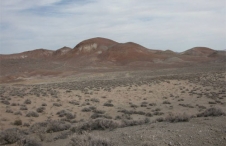
Basin and Range topography as seen from the crest of the Goshute Mountains. From a biological perspective, Great Basin mountains are like islands in a desert ocean.
Photograph courtesy Alan de Queiroz.
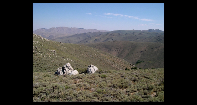
This range reaches a height of about 9,400 feet but, despite its height (and its name), it has remarkably little forest or woodland. The location of these mountains may explain their lack of trees. In particular, singleleaf pinyon, which colonized the Great Basin from the south, has not reached the area; slopes that might be covered with pinyon-juniper woodland are here dominated by sagebrush. Junipers occur only in a few small, isolated groves.
Photograph courtesy Alan de Queiroz.
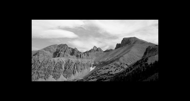
Mount Wheeler (right) and Jeff Davis Peak (left) in Great Basin National Park in the southern Snake Range. The Great Basin is a mountainous area, with hundreds of ranges. Mount Wheeler, at 13,063 feet, is one of the highest mountains in the region, surpassed only by peaks in the White Mountains on the California-Nevada border.

Image courtesy of T. Forbis.
Mount Moriah as seen from the Table, northern Snake Range. The Snake Range is about equally distant from the Rocky Mountains and the Sierra Nevada (and downwind of the Sierra) yet its flora is much more similar to that of the Rockies. Plant and animal species and subspecies in Great Basin mountains are more often Rocky Mountain than Sierran, perhaps because the climate and soils of the Great Basin more closely resemble those of the Rockies.
Photograph and caption courtesy of Library of Congress Prints and Photographs Division.
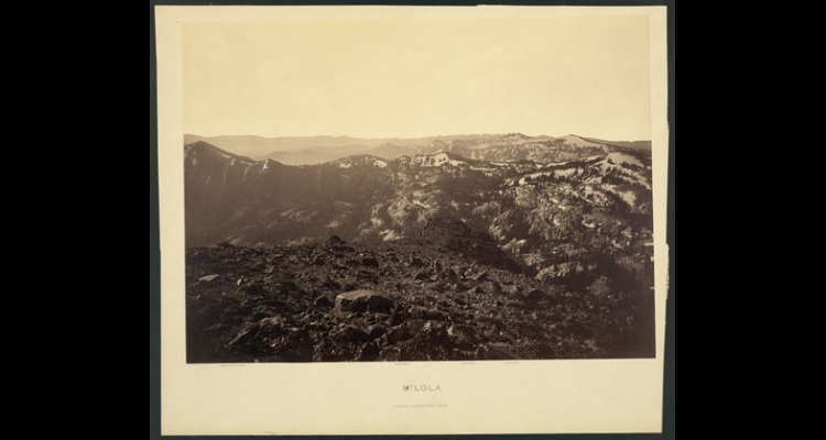
"Photograph shows a view from Mount Lola looking toward Lake Tahoe, with the 'Valley of the Truckee,' 'Rount Top,' and 'Castle Peak' in the distance. Carleton E. Watkins (1829-1916) photographer."This Library of Congress caption takes the place names directly from the original photo mount, which mislabels Round Top as Rount Top. Alternate iterations of the photo (as found at the Online Archive of California for example) include a new label that overlays the original place name identifiers on the mount with more detailed descriptors and the corrected spelling of Round Top.
Nevada lies almost entirely within the Basin and Range physiographic province. This vast area covers about 300,000 square miles and is surrounded by the Sierra Nevada and Cascade mountains on the west, the Columbia Plateau on the north, and the Colorado Plateau and Wasatch Front of the Rocky Mountains on the east. South of Nevada, the Basin and Range province extends into Mexico and parts of Arizona, New Mexico, and Texas. This entire region is tectonically active, characterized by down-dropped desert basins separated by a great many uplifted, predominantly north-south tending mountain ranges (there are 314 named ranges in Nevada alone). Most of the peaks are less than 10,000 feet in elevation, although a few top 13,000 feet. About half of the Basin and Range province is occupied by the Great Basin, a large area of isolated internal drainages that covers most of Nevada. (Rivers in the Great Basin flow toward its interior into closed valleys and do not reach the ocean.) Because the Basin is slightly dome-shaped with the highest valleys in the middle, all the lakes and all but one of the major rivers are near the western and eastern edges and are fed by snow that falls in the Sierra Nevada or Rocky Mountains. However, almost all valley floors throughout the Basin contain unvegetated playas, dry remnants of former lakes that existed in wetter times.
Topography and drainage patterns define five subdivisions of the Great Basin. The Central Area, covering most of the central and eastern part of Nevada, is the highest region with peaks over 13,000 feet and high, generally closed, valleys with average elevations of about 5,000 feet. Big Smoky Valley, stretching almost 100 miles from Austin to Tonopah, is typical. The natural vegetation of these valleys is sagebrush and salt desert scrub. Mountain ranges in the central area typically have pinyon-juniper woodlands in their middle elevations and sparse subalpine forests of bristlecone, limber, and white-bark pines on their highest peaks. The mountains in the eastern part of the Central Area, such as the Snake Range and the Schell Creek Range, are sometimes referred to as the calcareous mountains because they are largely composed of Paleozoic limestones and other carbonate rocks that were formerly ocean floor some 250 to 540 million years ago. In the western part, the mountains—such as the Toiyabe and Toquima ranges—are made of mostly volcanic rock. The differences in geological composition result in some interesting differences in species occurrences; for example, the calcareous ranges harbor a fairly diverse fauna of land snails while the volcanic mountains have almost none; this is because snails need calcium carbonate to construct their shells.
The second subdivision, the Bonneville Basin, covers most of western Utah and a small part of far eastern Nevada. The valleys are lower in this subdivision and were filled with Pleistocene Lake Bonneville about 18,000 years ago. Now only the Great Salt Lake, Utah Lake, and the usually dry Sevier Lake remain.
The third subdivision, the Lahontan Basin, is located between the Central Area and the Sierra Nevada. The valleys of this subdivision are lower in elevation than the valleys in the Central Area, about 4,000 feet on average. They were filled by Lake Lahontan and a few smaller lakes during the Pleistocene; because of the saline lake-bottom soils that remain, salt desert scrub is more common in the valley bottoms than sagebrush. The mountain ranges are volcanic and tend to be lower than the ranges in the Central Area. Some have pinyon-juniper woodlands, but many have no vegetation other than sagebrush all the way to the top; none supports subalpine conifers. Many of these ranges have been heavily overrun by cheat grass, perhaps because this invasive exotic weed does well in lower elevations and on volcanic soils. Almost all of the rivers in Northern Nevada are found in this subdivision. The Truckee River flows north and east from Lake Tahoe, the largest freshwater lake in the Great Basin, and terminates in Pyramid Lake. Although much of the Truckee's water has been diverted to agricultural uses in the Fallon area, Pyramid Lake has been guaranteed enough water to maintain its current level by the Truckee River Operating Agreement (TROAA). The Walker River originates in the Sierra Nevada and flows into Walker Lake—at least during very wet years. Most years, upstream diversions for irrigation siphon off the water before it reaches the lake. As a result the lake has dropped over 140 feet in depth and has lost 80% of its volume over the past century and soon will be too saline to support fish life. The Carson River also originates in the Sierra Nevada and terminates in the usually dry Carson Lake and the Carson Sink. Now, most of the Carson River's water is stored in Lahontan Reservoir, also eventually destined for agricultural uses. The Humboldt River originates in northern Elko County and flows in a southwesterly direction until it terminates in the Humboldt Sink near Lovelock. However, Rye Patch Reservoir intercepts most of the Humboldt's water before it reaches its final destination. Finally, two small rivers, the Quinn and Kings, originate in southern Oregon, flow southward, and terminate in the Black Rock Desert.
The fourth subdivision of the Great Basin in Nevada occupies the northwestern corner of the state—approximately the area north and west of the town of Gerlach. Geologically, it is the eastern part of the Modoc Plateau, a large volcanic highland that covers much of northwestern California and southeastern Oregon. The topography of this subdivision is different from typical basin and range; it shows less relief because faulting is less active and because lava flows have filled many of the older, lower basins. This subdivision is largely treeless, vegetated mostly with sagebrush, but occasional woodlands of western juniper and mountain mahogany can be found in some of the higher areas.
The fifth and final subdivision of the Great Basin is the Southern Area, south of the Central Area and east of the Sierra Nevada. It is lower in elevation than the Central Area, and includes Death Valley, California, with the lowest elevation in the United States and where much of the playa is encrusted salt. The vegetation of the valleys and lower mountain slopes is primarily creosote bush instead of sagebrush. A few mountains reach 10,000 feet and are well forested, such as the Spring Range near Las Vegas, but most ranges are below 8,000 feet. Part of the Southern Area, named "Walker Lane," reaches northward almost to Walker Lake and is a zone of active faulting extending north from the San Andreas fault. This low elevation zone, referred to as the "Lahontan Trough" by biogeographers, is also an important corridor for the past and possibly present movement of species from the Mojave Desert into the Lahontan Basin. The Lahontan Trough also may be a major barrier to the movement of Sierra Nevadan species eastward into the Great Basin.
Two small parts of Nevada are outside of the Great Basin and have external drainage. The first is in northern Elko County where the Owyhee and Bruneau Rivers and a few small creeks flow into the Snake River or its tributaries and eventually into the Pacific Ocean. Prior to the advent of dams on the Snake River, salmon actually came into Nevada to spawn in these waters. The second is in Southern Nevada where the Virgin and Muddy rivers drain into the Colorado River. The Colorado drains into the Gulf of California, but it no longer reaches the sea because all of its water is claimed for agricultural and municipal uses upriver.